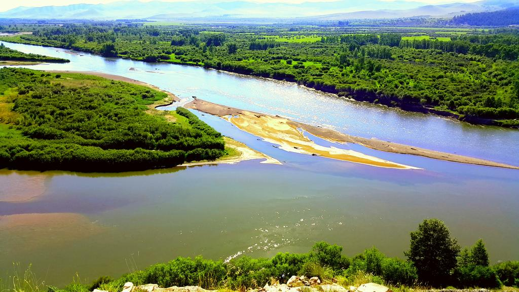
Kherlen river
It is called Kherlen from Bogd River and Tsagaan River pastures, which originate at 1,250 meters on the side of the Ikh Khentei mountain range. The length of the Kherlen River is 1264 kilometers, and it stretches 1090 kilometers from the confluence of the two rivers to the state border. The catchment area of the river is 116,455 kilometers, and alone constitutes 54% of the basin of the Pacific Ocean. The Kherlen River flows in the south direction at the beginning and gradually flows back to the east in Dalai Lake, which is located across the border. The river valley is 0.5-0.7 kilometers at the beginning, and it widens to 15-20 kilometers as it goes down from the mountains. The width of the river is 30-50 meters at the beginning, 150-200 meters at the end, the depth is 1-1.5 meters at the beginning, and the flow speed is 0.7-1.5 meter/seconds. 58-64% of the Kherlen River’s water supply is rainwater, 28-34% is groundwater, and 8-11% is water from melted snow.

The Tuul river
Originating in the Lower Khentii mountain range, it flows through Khentii, Central, Bulgan, Selenge provinces and flows into Orkhon, the longest river in Mongolia. Tuul River flows behind Bogd Khan Mountain into two branches, Haya River and Dund River, and then merges. The dense willow thicket that stretches for more than 60 kilometers from Uu bay down to Khuitnii Ongorkhoi is called Tuul’s black thicket. The Tuul River is a river that flows through the central and northern parts of Mongolia. It is 819 km long and has a catchment area of 49,840 kilometers. It will flow through Khentii, Central, Selenge provinces and Ulaanbaatar city. The elevation of the basin ranges from 770 to 2800 meters, and the highest point is Asralt Khairkhan mountain, which is 2799.3 meters above sea level, and the lowest point is the Orkhon-Tuul delta, which is 770 meters above sea level. The depth is 0.8-3.5. It originates from Khagi Khar Lake and Noming River, which are part of the Gorkhi-Terelj Natural Complex in the Nuruun of Khentii, flows through the southern part of the capital city of Ulaanbaatar and empties into the Orkhon River. It freezes from the middle of November to the middle of April.

Zavkhan river
The Zavkhan River is one of the largest rivers in Mongolia, located on the border of the Gobi-Altai and Zavkhan Provinces. The river originates from both sides of Otgontenger, the main peak of the Khangai mountain range water. In front of Otgontenger, the Buyant and Shar-Us rivers, which originate from the side, merge to form the Zavkhan river. In the valleys of the Buyant and Shar-Us rivers, there are dozens of lakes (the largest of which is Khokh Lake) with glacial sediments, and these lakes, which are connected by streams, pour their excess water into the Zavkhan River. The Zavkhan River departs from the Khangai Mountains and flows northwest towards the Great Lakes depression. The total length of Zavkhan River is more than 800 kilometers. The width of the first part of the channel up to Taishir Sum is 30-60 meters, the water depth is 0.6-25 meters, and the current speed is 1 1.5 meter/seconds. Below Taishir, it is difficult to distinguish the main channel because the channel branches from 3 to 8. From the right side of the Zavkhan River, its largest tributary, the Shura River, joins. Below the tributary of the Bogd River is raised to 100-350 meters the water depth is 0.7-1.5 meters, and the flow speed is 0.7-1.2 meter/second. Since the construction of the Ulaanboom Hydroelectric Power Station in 2008, the flow of the Zavkhan River has been blocked, and by 2011, about 300 kilometers of the watershed has been without water for three years.

Selenge River
It is the main water network of Mongolia, and if all the big and small tributaries are included, the total length of the water network reaches 20,000 km. In other words, more than 40% of the total length of the rivers of Mongolia is included in the Selenge river system. The pastures of Delger and Ider rivers The total length of the Selenge River is 1024 kilometers, 615 kilometers of which is in the territory of the country. The area of the Selenge River is 447,000 square kilometers, 55 percent of which, or 282,000 kilometers, falls on the territory of our country. The total river area belonging to the Selenge system is 87.3% of the Arctic Ocean area and 28% of the territory of Mongolia. In the first part of the river, the width of the channel is 60-70 meters, the width of the forks is 10-25 meters, the width of the channel is 2.5-3.0 meters in the middle, the width of the channel is 100-250 meters, and the water depth is 1.0-2.0 meters, it reaches 4-5 meters. Selenge River is considered to be the most mineralized among the major rivers of our country in terms of water composition and chemical structure, and it belongs to the rivers with hydrocarbon water. Delger, Ider, Hanui, Eg and Orkhon rivers are major rivers of our country in the Selenge River. poured. There is a fertile valley along the banks of the Selenge River. Dense willows and shrubs with larch and aspen grow. There is evidence that the Selenge River flooded in 1751, 1785, 1830, 1864, 1867, 1869, 1872, and 1897. The Selenge River freezes for 140-185 days from the second half of November to the end of April of the following year. The thickness of the ice is 67-167. The water temperature drops to 0 degrees in winter, and in the summer of 1973 it warmed up to plus 25 degrees. Selenge River is the largest tributary of Lake Baikal. Baikal Lake supplies 1/2 of the water. The source of the Selenge River breaks up into a very unique lake and flows into many streams. River delta is very large and covers an area of 680 kilometers. The average consumption of water is 310 meters/second near on the border of Russia and Mongolia, 127 kilometers, and 935 meters/second beyond. The Selenge River has 26 species of fish, which are important for hunting: pike, roach, perch, grayling, grayling, red-eye, etc. Valuable fish for hunting include: Siberian sturgeon, taimen etc. The Selenge River flows through a very beautiful valley, and the pastures of Eg-Selenge and Orkhon-Selenge are very beautiful. It is possible to develop tourism in this area. Selenge The shoulder is the main river for sturgeon migration and spawning is the place where it is pumped. The Selenge River flows through a very beautiful valley, and the pastures of Eg-Selenge and Orkhon-Selenge are very beautiful. It is possible to develop tourism in this area. Selenge The shoulder is the main river for sturgeon migration and spawning is the place where it is pumped.
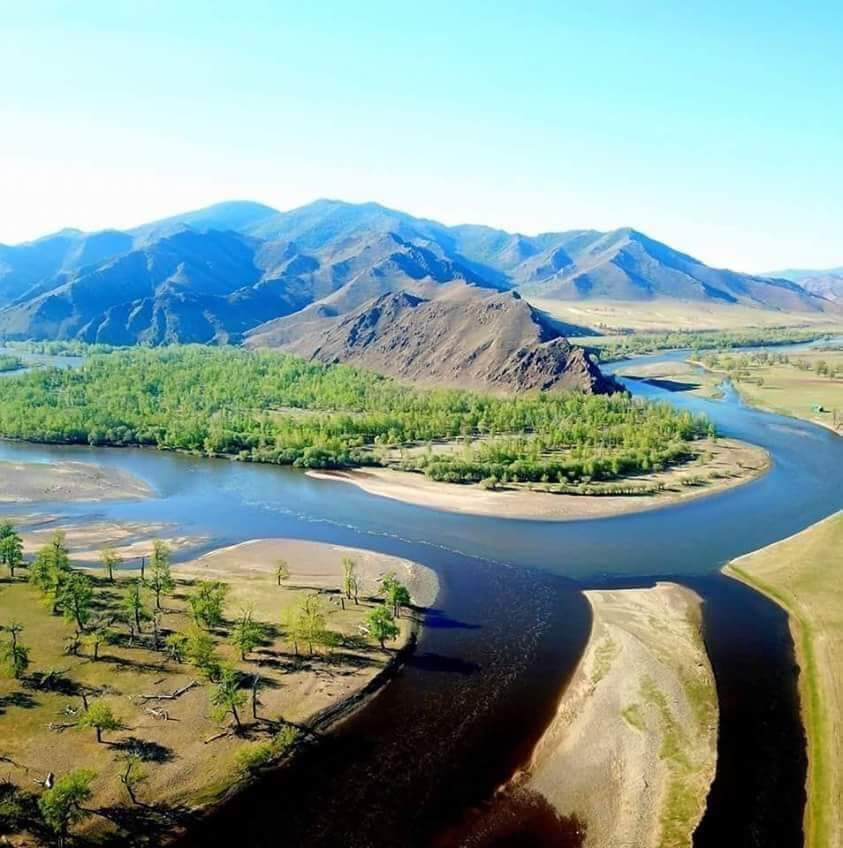
Orkhon river
It originates from Suvarga Khairkhan mountain in Hangai mountain range It is the largest tributary of the Selenge River, which flows for 1124 kilometers and joins near the city of Sukhbaatar. The catchment area is 132,835 kilometers, which is 47% of Seleng’s catchment area in our area. The first part of the Orkhon River is included in the Natural Complex of the Khangai Mountains. In the first part of Orkhon, many rivers such as Uliastai River, Tsagaan Gut River, Tongorog River, Tsagaan River, and Ulaan River join together. A little further down, there are many rivers such as Tamir River, Khavchu River on the left side, Naryn River (Khogshin Orhon), Tuul River, Khaara River, Yero River, and Sharyn River on the right. In the beginning, it flows through mountainous terrain, in the valley it has a deep gorge of cobblestones, and at the end it becomes very wide. After the confluence of the Tuul River, the Orkhon River flows into many branches, and the width of the river increases to 150 meters. After the confluence of the river, the water level rises rapidly. The valley of Orkhon has meadows and a large area of cultivation. Orkhon water is used for irrigation in Erdene-Zuu (Overkhangai) area. It has the capacity to irrigate 8150 hectares. There are a channel for the irrigation system. There are a 528 kilometers hydroelectric power station on the canal. This is the first hydroelectric power station in our country. It is believed that the Orkhon River can be used for waterways up to Tuul Adag. The valley widens to 10 km, the width of the river is 250 meters, the water depth is 3.5 meters, and the current speed reaches 2.5 meters/second. The density of the water network is 0.08 kilometers.
The Orkhon River is frozen in November for about 130 days. The depth is 3.5 meters, the flow speed is 2.5 meters/seconds. Orkhon foothills (in the vicinity of Sukhbaatar) are at an altitude of 602 meters. The average flow of water in Adag area is 116 meters/second, and the flow modulus is 0.76 l kilometers. Used for irrigation. There are fish such as roach, pike, blue whiting, perch, and gourd in Orkhon. The Orkhon river was the boundary behind the area where hunting of animals was prohibited in the vicinity of the 18th century law “Khalh procedure”. The territory of 53 sums of 8 provinces is included to some extent in the Orkhon river basin. The territories of Bulgan, Ulziit, Tibshruluag, Khotont, Bayan-Ondur, Orkhon Province, and Hujirt, Uverkhangai Province are all included. However, less than 0.5% of the territory of Orkhon River basin covers the territory of Orkhon River Basin. 38.2 percent of the Orkhon river basin is occupied by Arkhangai, 22.1 percent by Bulgan, 18.4 percent by Bayankhongor, 1.6 percent by Orkhon, and 0.4 percent by Darkhan-Uul province.